
DRILLING OF WATER WELLS
Groundwater of Azerbaijan
It is well known that usable water resources within the territory of the Republic of Azerbaijan are limited and unevenly distributed. Out of the average annual water resources of nearly 36 billion m³, about 21 billion m³ originate outside the country’s borders. The basins of the two main rivers that play an exceptional role in supplying water to the population of Azerbaijan—the Kura and the Aras—fully encompass the territory of Armenia, a large part of Georgia, as well as significant areas in Turkey and Iran. Consequently, they are already heavily polluted by the time they cross Azerbaijan’s borders.
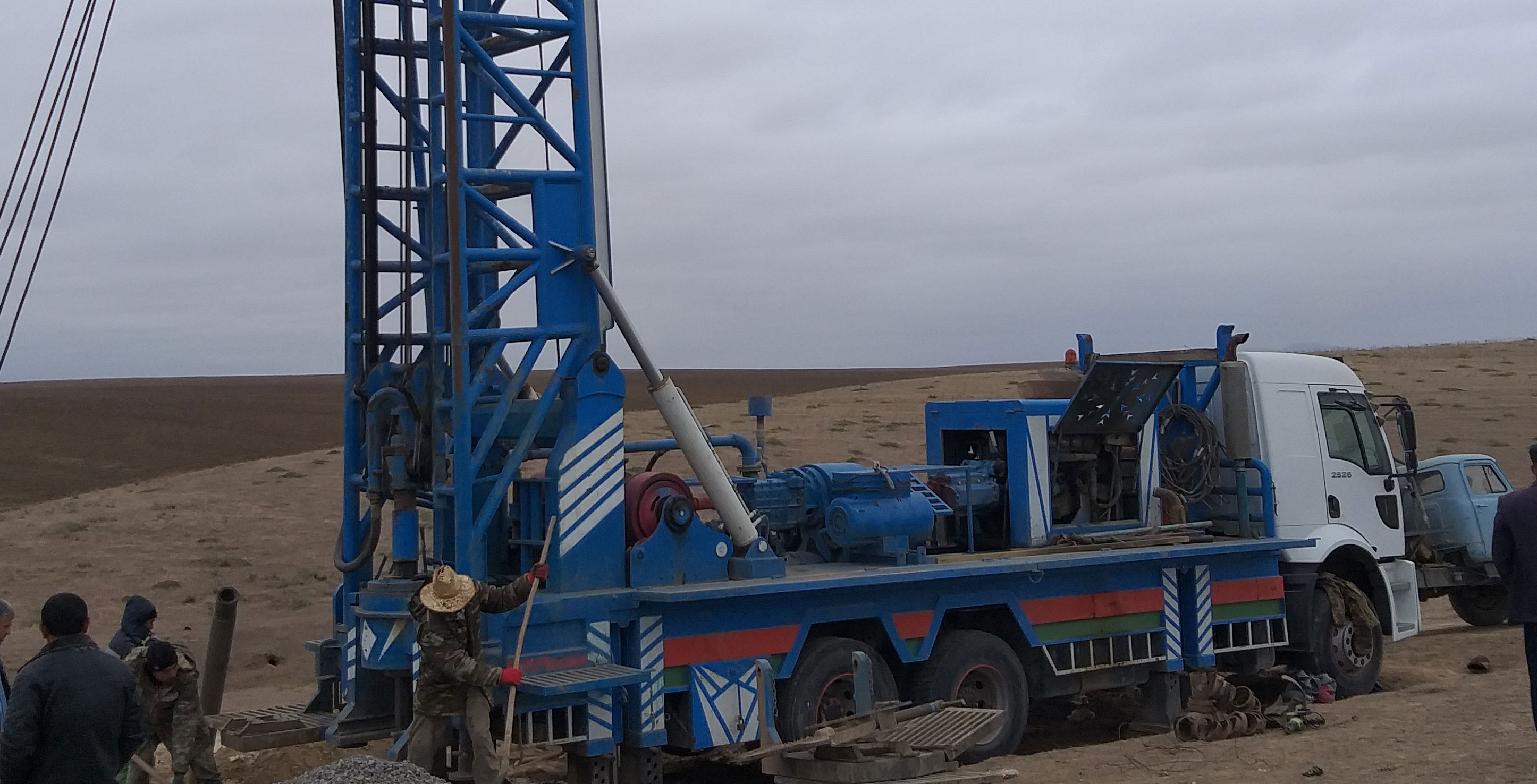
Water resources in Azerbaijan are extensively used for drinking and domestic purposes, as well as for irrigated agriculture, other sectors of agriculture, fisheries, hydropower, ecological, and other needs. The annual utilization of surface water resources in the country is around 11–12 billion m³, while the annual use of groundwater resources is approximately 2.5–2.8 billion m³.
Freshwater and Low-Mineralized Groundwater
Usable freshwater (mineralization rate up to 1.0 g/l) and low-mineralized water (1–3 g/l) occur across all genetic types in the country, ranging from Paleozoic rocks to modern sediments, and are unevenly distributed throughout mountainous and foothill regions.
-
Assessment: The regional exploitable groundwater resources of the foothill and lowland regions have been evaluated by the National Geological Exploration Service. In recent periods, hydrogeological studies have been conducted in certain regions (Karabakh-Mil, Ganja-Gazakh) to re-evaluate groundwater resources.
-
Approval: The regional exploitable resources of fresh and low-mineralized groundwater in the foothill plains of Alazan-Ayrichay, Samur-Shabran, Shirvan, Karabakh-Mil, Ganja-Gazakh, Nakhchivan, Lankaran, and others were approved or tested by the Resources Commissions of the former USSR and the Azerbaijan SSR.
Within the limits of regional exploitable resources (and in some cases, in new areas), precise hydrogeological exploration work has been carried out to meet the water needs of the country’s cities, towns, and rural settlements. Exploitable resources for centralized and group water intakes have been calculated and approved accordingly.
Current Status: Currently, the water supply for the population in more than 35 cities and towns in the Republic is fully or partially met by groundwater. This includes Baku, Sumqayit, Ganja, Agdash, Agstafa, Barda, Tartar, Nakhchivan, Ordubad, and others.
In mountainous regions, forecasted groundwater resources have been evaluated by administrative districts and total 1,806.9 thousand m³/day. It should be noted that, unlike the lowland and foothill zones, hydrogeological research aimed at assessing groundwater resources in mountainous areas has not been fully completed. Groundwater resources in the mountainous territories of Ismayilli, Quba, Qusar, Lerik, Yardimli, Gazakh, Tovuz, and other districts remain unassessed.
Recent Exploration and Assessments
In recent years, in line with the State Program on Social-Economic Development of the Regions, exploratory and reconnaissance work for groundwater has been conducted. Supported by preliminary geophysical surveys, searches for usable groundwater sources for various purposes were carried out in:
-
The Ceyranchol area of the western districts (Agstafa, Tovuz, Shamkir, Samukh), where winter pastures are located.
-
The areas of Ismayilli, Beylaqan, and Imishli, where local populations, particularly refugees and internally displaced persons (IDPs), are settled.
-
The districts of Lerik, Yardimli, and Khizi, as well as the “Harami” site in the Agjabadi district.
Currently, exploration and assessment work is continuing in the foothill areas of the Shaki district, the mountainous and foothill zones of the Siyazan-Quba districts (from Atachay to Valvalachay), and the Jalilabad district.
Exploitability and Regional Resource Figures
According to calculations conducted across various years, the regional exploitable groundwater resources of the country total 23,764.28 thousand m³/day (or approximately 9 billion m³ per year).
-
Approved by the Resources Commission: 12,079.4 thousand m³/day (including 126.4 thousand m³/day for mountainous regions).
-
Irrigation and Technical Use: Within these resources, 1,592.1 thousand m³/day of groundwater has a total mineralization between 1–3 g/l, making it suitable for irrigation and industrial purposes.
Despite the approval of exploitable groundwater resources across more than 60 fields for the water supply of cities and settlements, only about 20 centralized groundwater intakes are currently operational. According to official data from recent years, the volume of fresh and low-mineralized groundwater utilized constitutes 1.5% of regional resources and 26% of approved resources. Around 80% of the groundwater utilized is allocated to irrigation and technical purposes.
Forecasted Groundwater Resources by Region (Up to 2014)
The table below illustrates the forecasted resources of usable groundwater within the territory of the Republic of Azerbaijan, evaluated up to 2014:
| Regions with Usable Groundwater | Forecasted Resources Evaluated in 2014 (thousand m³/day) |
| Greater Caucasus Mountainous Region | 1,008.87 |
| Absheron Peninsula | 241.92 |
| Samur-Davachi Foothill Plain | 3,470.72 |
| Ganikh-Ayrichay Valley | 3,822.00 |
| Ganja Foothill Plain | 4,218.60 |
| Shirvan Foothill Plain | 517.70 |
| Karabakh-Mil Foothill Plain | 7,909.92 |
| Mugan Foothill Plain | 130.00 |
| Jabrayil Foothill Plain | 344.00 |
| Lankaran Foothill Plain | 209.00 |
| Nakhchivan Foothill Plain | 902.20 |
| Lesser Caucasus Foothill Plain | 982.35 |
| Total for the Republic: | 23,764.28 |
Thermal, Industrial, and Mineral Waters
The territory of the Republic of Azerbaijan is also rich in thermal waters of thermal-energy significance, as well as highly mineralized thermal and hydro-mineral raw waters of sanatorium-therapeutic value located in the deep horizons of the subsurface.
Azerbaijan was one of the four republics within the former USSR possessing explored reserves of industrial iodine-bromine waters. It ranked second in the Union for its explored reserves (31.5%) and first for the volume of iodine production.
Iodine-Bromine Water Deposits
Explored industrial iodine-bromine waters are concentrated in 5 main fields within the Republic: Neftchala, Khilli, Babazanan, Mishovdag, and Bina-Hovsan. The first four fields are located in the southeastern part of the Kura Depression, while the Bina-Hovsan field is situated on the Absheron Peninsula.
As a result of exploration and drilling activities, deep-well drilling and hydrogeological testing were carried out on iodine-bromine waters in various structures:
-
Absheron Peninsula: Bina-Hovsan trough (Qala-Turkan, Surakhani-Garachukhur, Buzovna-Mashtaga, Zigh-Hovsan) and Western Absheron (Lokbatan-Gushkhana, Yasamal Valley, Shabandag, Atashgah, and Sulutepe).
-
Lower Kura Depression: Neftchala, Khilli, Babazanan, Mishovdag, Kursangi, Kirovdag, Garabaghlia, Alat, and Khidirli-Pirsaat.
-
Caspian Region: Sitalchay, Gadisu, and Shuraabad.
Through these works, the hydrodynamic and hydrochemical parameters of the water complexes of the “Productive Stratum” sediments were determined. Reserves for the Bina-Hovsan, Neftchala, Khilli, Babazanan, and Mishovdag deposits were calculated and approved by the State Resources Commission of the former USSR.
Deep groundwaters associated with the Mishovdag, Babazanan, Khilli, and Neftchala deposits (located in the Absheron Peninsula and the Lower Kura depression) have temperatures ranging between 35–65°C. Due to high chemical mineralization (up to 210–220 g/l), they are classified as industrial-grade iodine-bromine waters. Currently, “Azer-Yod” LLC is engaged in technical iodine production based on the groundwater of the Neftchala and Khilli deposits.
Hydrogeothermal Zoning and Resource Potential
Over the years, hydrogeological studies were also conducted to explore groundwater containing alkaline, soda, rare metals, and other hydro-mineral raw materials. These targeted areas included the flanks of the Baku trough, Zira, Binagadi, Kurdakhani, Qaraheybat, Yasamal Valley, Bibiheybət, and Atashgah on the Absheron Peninsula; Novoastrakhanka and Cheviildag in the Shamakhi-Gobustan oil and gas region; Shorsulu, Muradkhanli, Jarli, and Zardab in the Kura depression; Gadisu, Yalama, Zaghli, Zeyva, Chandahar-Zarat, Qaynarja, Talabi, Tangialti, and Saadan in the Caspian oil and gas province; and Tarsdallar, Koyruk-Keylan, Boyuk Palantokan, Sajdag, and Udobna in the Kura-Ganikh interfluve oil and gas province. A technical-economic report was prepared regarding the feasibility of utilizing the soda waters of Western Absheron.
As a result of dedicated hydrogeological research on thermal waters initiated in the early 1960s and continued until the late 1990s, 9 hydrogeothermal regions were identified in Azerbaijan based on their structural, hydrogeothermal, and geothermal conditions, as well as their suitability for use in various sectors of the national economy:
-
Caspian-Quba
-
Lankaran Sloping Plain
-
Absheron Peninsula
-
Shamakhi-Gobustan
-
Kura Depression
-
Jalilabad-Zar
-
Ajinohur
-
Kura-Ganikh Interfluve Area
-
Nakhchivan
Exploration and preliminary reconnaissance work expanded significantly from the 1960s onward to study the hydrodynamic, hydrochemical, and hydrothermal characteristics of these water complexes. This work intensified in the early 1980s in the Yalama-Khachmaz sectors of the Caspian-Quba region and along the southwestern flanks of the Kura depression.
Consequently, Technical-Economic Reports (TER) were prepared for several areas (Lankaran, Ganja), and a Technical-Economic Feasibility Study (TEFS) was developed for the Caspian-Quba thermal water field, alongside the calculation of exploitable thermal water reserves.
Total Reserves: The total reserves of thermal and industrial waters within the territory of the Republic of Azerbaijan have been calculated at 419,093 m³/day.
Medicinal and Mineral Water Sources
Furthermore, hydrogeological studies were conducted at 16 medicinal-table and 14 therapeutically significant mineral water sources across Azerbaijan. Their exploitable reserves were calculated and approved by the State Resources Commission of the former USSR. These sources include:
-
Ilisu, Chagan, Chukhuryurd
-
Sirab (4 deposits), Vaykhir (2 deposits), Badamli (2 deposits)
-
Daridagh, Shirlan, Turshsu, Minkand
-
Yukhari Istisu, Ashaghi Istisu, Tutkhun, Mozchay, Qoturlu, Keshdak
-
Qarasu, Qalaalti, Meshesu, Ibadisu
-
Surakhani, Mardakan, Pirshaghi, Buzovna, and Bilgah.

GEOLOGICAL ENGINEERING
Engineering Geology
Engineering geology is a branch of geological science that studies the geological conditions and dynamics of the upper layers of the Earth’s crust in relation to human engineering activities. Based on engineering geological investigations, the most suitable locations and favorable designs for construction projects are determined, along with appropriate construction methods. Furthermore, measures are established to counteract geological processes that may occur due to the impact of construction and interfere with its normal operation.
Based on engineering geological investigations, the following are studied:
-
a) The rate and limit of rock/soil compaction under the weight of the structure;
-
b) The resistance of the rock/soil against being squeezed out from under the foundation;
-
c) The stability of walls in foundations, quarries, canals, and other excavations;
-
d) The stability of a reservoir dam against the pressure of the reservoir water;
-
e) The erosion of reservoir shorelines;
-
f) The stability conditions of building foundations in areas with rising groundwater levels;
-
g) The stability of structures built in seismic, karst, landslide, and other hazardous zones.
DRILLING OF GEOTERMIC WELLS
Thermal Waters
Scientific and practical research is being conducted in many developed countries around the world to solve the problems of utilizing non-traditional energy sources, such as solar, wind, and underground thermal waters. The characteristics of thermal waters—acting as accumulators of subsurface thermal energy and possessing high heat-energy capacity—distinguish them as an energy carrier of special importance among non-traditional energy sources.
In Azerbaijan, geological exploration work was carried out between 1964 and 1970 in the Talysh zone (Astara, Lankaran, and Masalli districts) to study thermal waters. For this purpose, 17 exploration wells were drilled, and thermal waters with temperatures ranging from 38°C to 64°C were discovered in all of them. To utilize them for thermal energy, 10 greenhouses were established for growing early vegetables (tomatoes, cucumbers), and the feasibility of harvesting crops 2 to 3 times a year was demonstrated.
Thermal waters were also encountered in deep oil exploration wells (3,200–4,500 m) drilled in the Jarli structure; their total flow rate was 2,500 m³/day, with surface temperatures reaching 72–97°C.

Through exploration wells drilled up to a depth of 3,000 meters in the Caspian (Khudat-Khachmaz) zone, thermal waters with a total flow rate exceeding 30,000 m³/day and surface temperatures ranging between 50°C and 81°C have been discovered.
Exploration of the Khudat-Khachmaz thermal water deposit, discovered within the Guba-Khachmaz zone, has been conducted, and its exploitable reserves were approved at 25.7 thousand m³/day and officially registered in the State Balance.
Despite the widespread distribution of thermal waters across the country’s territory, their utilization in various sectors of the economy remains unsatisfactory. Currently, the geological exploration wells drilled for thermal waters in the Khachmaz district are only partially used for therapeutic and domestic-communal services.
Forecasted Exploitable Reserves of Thermal Waters Across the Republic
The country’s forecasted exploitable thermal water reserves are evaluated as follows:
-
Southern slope of the Greater Caucasus: 2,000 m³/day ($t$: 30–50°C)
-
Guba-Khachmaz zone: 21,000 m³/day ($t$: 40–85°C)
-
Absheron Peninsula: 20,000 m³/day ($t$: 40–90°C)
-
Mountainous part of the Lesser Caucasus: 4,000–5,000 m³/day ($t$: 30–74°C)
-
Nakhchivan AR: 3,000 m³/day ($t$: 40–50°C)
-
Talysh mountainous region: 15,000 m³/day ($t$: 31–43°C)
-
Lankaran plain: 7,000–8,000 m³/day ($t$: 44–64°C)
-
Kura depression: 170,000 m³/day ($t$: 30–71°C)
-
Total for the Republic: 249,000 m³/day
Key Takeaway: The analysis of geological data from thermal water fields indicates that the total exploitable reserves of thermal waters are actually several times higher than the figures stated above.
The comprehensive study of underground thermal waters—as an ecologically clean energy source—alongside conventional fuel types (primarily oil and gas) and their integration into public service is of great importance. Currently, the National Geological Exploration Service is conducting specialized research to determine specific directions for utilizing the thermal waters discovered across the territory of the Republic.

DRAINAGE DRILLING
Drainage (Draining)
It is the artificial removal of groundwater or surface runoff to dry the soil or land. Open drainage involves releasing water into ditches or canals through surface trenches, while closed drainage utilizes underground pipes to direct water into ditches or canals.
During land reclamation, drainage is categorized by purpose:
-
Drying drainage is used to drain excess water;
-
Desalination drainage is used in arid regions to combat soil salinization;
-
Aeration drainage is used in heavy clay soils to enhance gas exchange.
In agriculture, two main types of drainage networks are implemented:
Horizontal Drainage
This type of drainage itself is divided into two categories:
-
Open Drainage: Canals are carefully positioned so that they do not obstruct the mechanization of agricultural work in the field or the construction of temporary irrigation ditches.
-
Closed Drainage: This method is used to prevent soil loss. The depth of the channels usually ranges from 2.5 to 3 meters, and the distance between the drains varies between 200 and 800 meters.
Vertical Drainage
Drainage systems are also utilized to protect buildings and structures from the impact of groundwater. These consist of engineering structures (such as kahriz systems, wells, underground galleries, etc.) that collect and divert water.
When lowering the overall groundwater level across a construction site (which typically needs to be maintained at a depth of 3–3.5 meters below the ground surface) does not yield the required effect, localized drainage systems are applied. These include bed (under-slab) drainage, foundation wall drainage, and ring (perimeter) drainage.

CAROTAJ WORKS
Well Logging (Karotaj)
Well logging consists of borehole geophysical investigations conducted to identify mineral resources (oil, gas, coal, various ores, etc.) in a geological section, study well sequences, and solve other geological problems. Depending on which physical or chemical parameters are being studied within the section, various logging methods—such as electrical, radioactive, acoustic, and gas logging—or a combination of them are utilized.
The specific suite of logs (integrated logging) is selected based on the target mineral resource being explored, the geological structure of the region, the technical drilling conditions, and other relevant factors.
The data obtained during the logging process is recorded using equipment built into a logging truck or station. The resulting log plot (log diagram) reflects the continuous variation of the studied parameters along the well section at a given scale.
Some researchers consider it more appropriate to use the terms “method”, “-metry” (for example: radiometry, gamma-ray method), or “Borehole Geophysical Investigations” instead of the term “well logging”.
HORIZONTAL DRILLING
Recently, horizontal directional drilling (HDD) rigs have been widely used around the world for installing underground utility lines. The main advantage of this trenchless method is that utility lines can be installed beneath surface structures (highways, railways, canals, as well as multi-story buildings) without damaging them.
The international company “Forward HDD” specializes in the manufacturing, servicing, and sales of horizontal directional drilling (HDD) rigs designed for the installation of underground utilities.
These directional drilling rigs possess a pulling force ranging from 10 to 150 tons. A crew of 3 to 5 members operates these machines. You can contact our company for your horizontal directional drilling needs.
